

Recently, I attended a wedding reception of a family member, and because I didn’t know exactly where this event was being held, I opened a common mapping application on my cell phone and entered the desired address. Once I tapped GO, I received accurate real-time updates on my location relative to the location of the wedding reception. En route, I received information about pertinent weather, road and traffic conditions, along with a current ETA. This information made a potentially painful traveling experience into a simple and comfortable drive. Like you, I have not only become accustomed to such information, but I have found myself getting irritated or even incensed when on occasion something goes wrong with some part of this system.
While you may not have attended a wedding reception this past weekend, I’m very confident you know exactly what I am talking about with your own dependence on such great technologies. I am equally confident you will be surprised to learn that these and hundreds of other related technologies in the United States are in serious jeopardy of a collapse unless we address what is becoming known as “The Geodesy Crisis” named such by 15 of the top Geodesists in the United States, as described in a white paper released for public consumption on Jan. 1, 2022. This article is now almost two years old, and little has been done in response to its claims. This brief article is intended to inform you of this crisis, what it means to us as professional engineers and surveyors, and perhaps a few action items we can take to thwart at least some of the negative impacts of this crisis.
What is Geodesy?
A common definition is:
“The applied science for determining the size and shape of the Earth, designing and realizing reference frames, and determining where you (and anything else) are on the Earth.” (Zilkoski, 2020)
How does Geodesy affect me as an Engineer or Surveyor?
In another article for GPS World, author and former National Geodetic Survey (NGS) Director David Zilkoski said:
“The advancements in satellites and computers have enabled geodesy to expand into many different disciplines. Geodetic science and technology now underpin many sciences, large areas of engineering (such as driverless vehicles and drones), navigation, precision agriculture, smart cities and location-based services. Geodesy is actually more important than ever.” (Zilkoski, 2020)
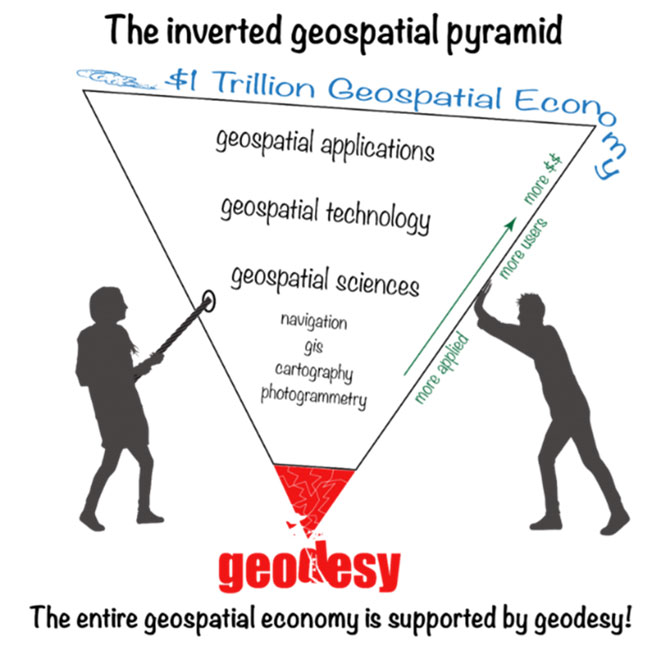
The inverted geospatial pyramid helps to illustrate how the $1 trillion-dollar Geospatial Economy is based on Geodesy. If you look carefully at this illustration, you will note near the top of the pyramid “Geospatial Applications” and in the smaller print near the bottom “navigation, GIS, cartography, and photogrammetry.” Each of these disciplines and their associated product applications affect the everyday work of civil engineers and surveyors along with many others. Instruments and equipment like GPS which is one of several Global Navigation Satellite Systems (GNSS) and Drones with Remote Sensing (Aerial Photogrammetry and LiDAR) applications, GIS and mapping based on projections of the earth’s surface, etc. not to mention the typical, less accurate GPS used on our cell phones to navigate to the job site or even a wedding reception. Imagine for a moment not having these technologies working accurately, precisely and harmoniously every day. We should be able to get a good idea of what it would be like from the few times they don’t work perfectly. What a mess we would be in!
What is the “Geodesy Crisis”?
“The future of precision missiles, as well as drones, driverless cars, super-precise synchronized clocks, and navigation of the Moon and Mars, depends on a specialized science called geodesy, a field Americans dominated a generation ago — but have almost entirely abandoned.” (Zilkoski D. B., 2022)
In a few words, we are now at a place in the United States where we have such a small number of Geodesists that the number could be considered zero. At the same time, some of the European countries have many more Geodesists than the U.S. and China has more Geodesists than all the countries in the world combined.
In a white paper released on Jan. 1, 2022, by 15 of the top Geodesists in America, they address this very issue. They titled the paper, “America’s Loss of Capacity and International Competitiveness in Geodesy.” This paper states:
“The U.S. is on the verge of being permanently eclipsed in geodesy and in the downstream geospatial technologies. This threatens our national security and poses major risks to an economy that is strongly tied to the geospatial revolution, on Earth and, eventually, in space.” (Bevis, 2022)
They conclude with this statement:
“GPS … really launched the geospatial revolution and what is now a vast geospatial economy. GPS drove an explosion of scientific and technological creativity that extended far beyond the original conception of ‘positioning, navigation and timing.’” (Bevis, 2022)
This white paper goes on to explain more details about this crisis. Essentially stating that the U.S. Government, mostly the DOD, began significantly reducing funding for academic research and graduate training in geodesy in the early 1990s because the predominate thinking at the time was that there is “no need to fund geodesy research … because all important geodesy problems were solved” with the advent of GPS. This ignorant attitude, along with China’s increasing investment in academic research over the past three decades, has placed China at or near the top of geodesy knowledge, putting them at the cutting edge of all technologies flowing from this basic science.
“The U.S. disinvestment process not only restricted basic research in pure and applied geodesy, thereby reducing the flow of the new ideas and knowledge that drive innovation in our geospatial technologies, it has done tremendous damage to academic programs in geodesy as well.” (Bevis, 2022)
The number of Geodesy programs in the United States has been essentially reduced to a few departments in a few universities. At the present time, the U.S. government generally, the DOD and university administrators are unaware of the crisis we now face. If you continue to disinvest in Geodesy, the scientific knowledge and its outflows in technologies and applications will only be available in Europe or China. This seems far from ideal for many reasons which are beyond the scope of this article. Suffice it to say, if something significant isn’t done soon we could see a deterioration in many systems, products and applications dependent upon the basic science of geodesy. We are becoming increasingly vulnerable to other countries because they will be dictating to the U.S. what and how we can apply these technologies.
What can we do as engineers and surveyors?
“The Geodesy Crisis” white paper suggests two “recovery mechanisms”:
- Greatly expanded training and recruitment (Bevis, 2022)
- Greatly expanded research and technical development (Bevis, 2022)
Additional action items could include the following:
- Raise awareness at every applicable level of government (lawmakers and bureaucrats).
- Encourage and seek funding for basic geodesy scientific research.
- Encourage and incentivize enrollment in Science, Technology, Engineering, and Mathematics (STEM) programs in high schools, colleges and universities.
Encourage and seek funding support for undergraduate programs not only in STEM degrees generally but also in Surveying, Mapping, and Engineering degrees (these degrees produce graduates that could potentially further their education in STEM graduate programs, specifically Geodesy). - Seek funding for workforce development to incentivize and employment in the STEM workforce, specifically:
- Surveying and Mapping
- Civil Engineering
- STEM — specific to Geodesy
- Companies that use geospatial technologies and applications can begin funding employees to become educated in STEM programs, specifically:
- Surveying and Mapping
- Civil Engineering
- STEM — specific to Geodesy
- Encourage and incentivize colleges and universities to focus more on job market demand than on enrollment numbers including student recruiting efforts and student incentive programs like scholarships, tuition waivers, or other mechanisms which will increase enrollments in high-demand disciplines like geodesy.
Conclusion
The list of action items above is not exhaustive nor specific, but with careful thought and concerted effort on the part of government officials, university administrators, business owners and concerned citizens, they can develop viable solutions which could alleviate the Geodesy and Geospatial Crisis in the United States. Maybe then you and I will continue to enjoy new and exciting geospatial technologies and applications that improve our productivity and our personal lives.
Works Cited
Bevis, e. a. (2022, January 1). The Geodesy Crisis. Retrieved from The American Association of Geodetic Surveying:
https://aagsmo.org/the-geodesy-crisis/
Zilkoski, D. B. (2020, July 20). Number of trained US geodesists at crisis level. Retrieved from GPS World:
https://www.gpsworld.com/number-of-trained-us-geodesists-at-crisis-level/
Zilkoski, D. B. (2022, November 1). The inverted geospatial pyramid shows our vulnerability. Retrieved from GPS World:
https://www.gpsworld.com/the-inverted-geospatial-pyramid-shows-our-vulnerability/