Ben Willardson, PE, Ph.D. — CWE and Mike Rau — CUWCD
Fire plays an important role in most wildland ecosystems. Vegetation often depends on fire to create a period of rebirth by removing dead materials and releasing nutrients back into the environment (Ainsworth and Doss, 1995). Across the United States, wildfires burn more than 4 million acres annually, costing Federal agencies above $768 million a year (1994-2002) in suppression alone (Butry et al., 2008). Some of the most well-known fires have burned large sections of famous national parks such as Yellowstone and Yosemite.
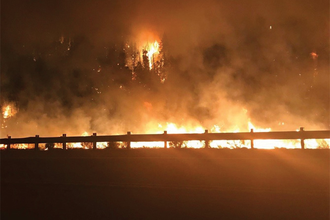
Utah was impacted by several fires in 2018, including the Dollar Ridge, Bear Trap, Coal Hollow, Pole Creek, Notch, and Willow Creek Fires. Estimates of the burned watershed areas are over 200,000 acres, or over 300 square miles of forest lands. These fires have impacted many watersheds that provide water supplies for cities and towns throughout Utah. These fires set the stage for impacts to highways, drinking water systems, and dwellings. The impacts to the Duchesne Valley Water Treatment Plant operated by the Central Utah Water Conservancy District is provided as an example of the impacts faced by civil engineers after a fire. See Figure 1 (featured image above).
Between the 1930s and 1970s, firefighting tactics and equipment became increasingly more sophisticated, effective fire suppression efforts increased dramatically, and the annual acreage consumed by wildfires in the lower 48 states dropped from 40 to 50 million acres a year (Laverty, 2001). Across the Western United States, the aggressive fire-suppression policies appeared to be successful. However, these policies have set the stage for the intense fires experienced over the last few decades.
Many fires are caused by lightning. Others are human-made
Full fire suppression allowed forests and wildlands to grow without the effects of fire, disrupting ecological cycles and changing the structure and makeup of the forests (Laverty, 2001; Pierson, Jr. et al., 2003). Other vegetation that had been regularly eliminated from forests by periodic, low-intensity fires, became a dominant part of the forest. This vegetation became susceptible to insects and disease, which left dead trees, mixed brush, and downed material to fill the forest floor. The accumulation of materials, when dried by extended periods of drought, creates the fuels that allow extremely large fires to burn across large areas of forest and wildland (Laverty, 2001).
Changes to Vegetation and Soils During Fires
Fire in forested areas is an important natural disturbance mechanism that plays a role of variable significance depending on climate, fire frequency, and geomorphic conditions. The role of fire is particularly important in regions where frequent fires, steep terrain, vegetation, and post-fire seasonal precipitation interact to produce dramatic impacts (USDA, 2005). The amount of vegetation consumed by a fire depends on the fire regime and fire severity (USDA, 2005). The USDA (2005) provides an in-depth discussion of fire regimes and severities. Low-severity fires rarely produce adverse effects on watershed hydrologic conditions, while high-severity fires generally result in higher runoff and erosion.
Wildfires can leave large areas devoid of vegetation and vulnerable to producing large volumes of runoff, leading to flash floods, floods, or mudslides (NOAA, 2004). The high rate of runoff following brush fires may result from the combined effects of denudation and formation of a water-repellent soil layer beneath the ground surface (Nasseri, 1988). The type of vegetative cover on soil changes the infiltration rates. The change is due to the effects of vegetation on slowing surface runoff velocities. Loss of surface litter, vegetative basal cover, and the associated microtopographic relief also reduce surface storage of water crucial for reducing runoff and increasing infiltration (Pierson, Jr. et al., 2003). The removal of vegetation due to fires increases runoff as surface runoff velocities increase, decreasing the time available for infiltration. Fires also change soil characteristics.
Fires induce temperatures at ground level, reaching 600 to 700 degrees centigrade. Burning vegetation, especially chaparral, releases oils, resins, and waxy fats stored in plants and plant litter as intense heat vaporizes the vegetation (McPhee, 1989). The soil acts as an insulator, keeping temperatures a few centimeters below the surface much cooler. This temperature difference allows condensation of vaporized substances, forming a hydrophobic layer. This layer is impermeable and prevents water from reaching all but the first few inches of soil. It also slows evaporation through the soil (Ainsworth and Doss, 1995). The extent and depth of a hydrophobic layer both depend on the type of soil, the fire intensity, and antecedent soil moisture. Clay soils tend to resist the formation of a hydrophobic layer. Sandy and sandy loam soils are far more susceptible to hydrophobic conditions (DeBano 1987).
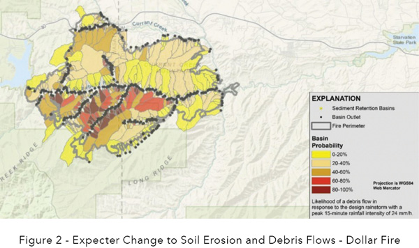
If a drop of water is placed on a pre-burn sample of sandy loam soil, the water will all but disappear. If the same water drop is placed on a post-burn sample, the drop will ball up and may remain there for hours. Water quickly saturates the thin layer of permeable soil above the hydrophobic zone because a vegetative canopy is not slowing it down. Slower infiltration rates result in an increased intensity of surface runoff and erosion. These changes to the soil and vegetation lead to higher soil erosion rates. Figure 2 shows the expected probabilities of debris flow in watershed areas due to impacts from the Dollar Fire area above Starvation Reservoir.
Changes to Runoff After Fires
Fire changes the soil and vegetation characteristics of a watershed. The changes result in higher runoff rates and more erosion within the watershed. Erosion of sediment leads to bulking of flows, where entrained sediment increases the volume of runoff. Vegetation, litter, rocks, and other forms of ground cover create barriers that slow and spread water movement across the soil surface, allowing more time for water to infiltrate over a larger surface area. Fire removes most of these barriers and allows the water to concentrate into rills. Rills allow increased flow depth and velocity. Higher flow depths and velocities significantly decrease runoff response time and increase runoff volume in streams (Pierson, Jr. et al., 2003). Several studies have been conducted to determine the influence of fire on the volume and peak runoff from watersheds.
Work by Davis (1977) suggests that many post-fire flows are debris flows. In the watersheds that Davis studied, he found that bulking ratios in runoff ranged from 0.5% to 2.5% by volume for normal flows to 40% to 60% by volume for post-fire flows. Bulking can increase runoff volumes and peaks significantly. However, it will not be evaluated further in this study
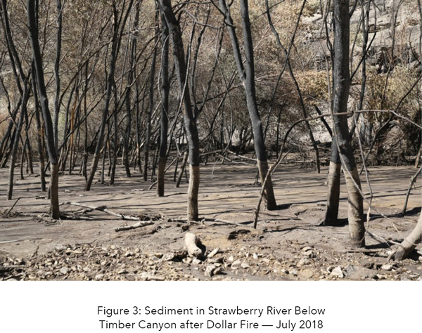
Veenhuis (2002) studied two burned watersheds in New Mexico. He noted that storm flows increased dramatically after the wildfire. Peak flows in each of these two watersheds increased to about 160 times the maximum-recorded flood before the fire. As vegetation reestablished itself in the second year, the annual maximum peak flow was reduced to approximately 10 to 15 times the pre-fire annual maximum peak flow. During the third year, maximum annual peak flows were reduced to about three to five times the pre-fire maximum peak flow. In the 22 years since the La Mesa wildfire, flood magnitudes have not completely returned to pre-fire magnitudes. The number of larger than normal peak flows seems to be most pronounced for three years after the fire. (Veenhuis, 2002). Other studies also indicate significant increases in the runoff after a fire (Pierson, Jr. et al., 2003; Nasseri, 1988; Wondzell et al., 2003). Figure 3 shows sediment deposited in the Strawberry River floodplain after rainfall in July 2018.
Watershed Recovery From Fires
The vegetation of chaparral communities has evolved to a point where it requires fire to spawn regeneration. Many studies have shown an increase in runoff and erosion rates the first year following a fire, with recovery to pre-fire rates generally within five years (Wright and Bailey 1982). The timing and extent of recovery are highly dependent on precipitation, slope, and vegetation type (Branson et al. 1981, Wright et al. 1982, Knight et al. 1983, Wilcox et al. 1988). Pierson, Jr. et al. (2003) noted that water repellency of the hydrophobic water layer deteriorates over time, resulting in a gradual recovery in the infiltration capacity of the soil.
Other studies have numerically quantified the Ainsworth and Doss (1995) qualitative summary. Pierson, Jr. et al. (2003) studied two watersheds in Idaho that were severely burned. They note that virtually all vegetation and litter was consumed during the fire. Bare ground for all burned sites was greater than 95% resulting in increased soil exposure to the erosive forces of raindrop impact and overland flow. It took two growing seasons and three winters for litter accumulation to reduce the amount of bare ground on the burned sites to near 50%. Watershed vegetation recovers to 90% of the pre-fire condition after five years. These results are consistent with the results of the other researchers, both quantitatively and qualitatively
Local Impacts and Civil Engineering
Fires and post-fire impacts often impact built infrastructure and utility systems that are operated by civil engineers. These impacts include higher runoff volumes, debris flows, and impacts on water quality. One example of impacts to facilities in Utah in 2018 includes impacts on watersheds and water supply systems.
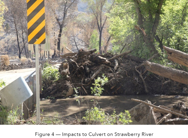
Figure 4 shows debris from the fire was washed down to the culvert during a summer thunderstorm.
Another impact with long-term implications is the generation of higher than normal sediment loads in the flows from the watershed. The Dollar Ridge Fire burned the watershed tributary to Starvation Reservoir. The Central Utah Water Conservancy District operates the Duchesne Valley Water Treatment Plant (DVWTP) that draws water from Starvation Reservoir for treatment and distribution. The plant is the only water supply for parts of Duchesne County.
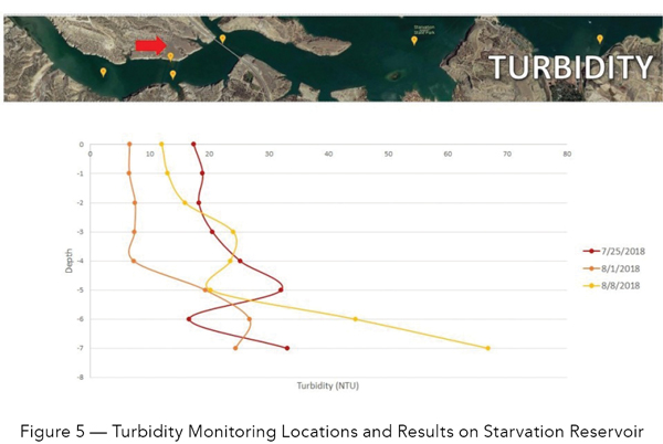
After the fire and initial assessment, CUWCD was concerned with the operation of the plant in the impacted system. The pollutants of concern included turbidity, nutrients, algae growth, organics, disinfection byproducts (DBPs) and dissolved oxygen. Turbidity from increased sediment has the potential to impact the treatment and filtration systems, as well as impact fish within the reservoir. Nutrients, such as phosphorous, increase the potential for algae growth, which then interferes with the filtration processes and has the potential to cause cyanobacteria blooms. Increased organics in the water cause more disinfectant demand, which leads to increased disinfection by-products (DBPs), and can also change both the taste and odor of the water delivered to end-users. Increases in suspended solids can cause lower dissolved oxygen, reducing the oxygen available for fish within the reservoir. Figure 5 shows the results of sampling on several days at one of the monitoring locations in the Starvation Reservoir.
The water intake from Starvation Reservoir near the DVWTP intake is usually less than 3.0 NTU. As a direct filtration plant, the DVWTP cannot treat high turbidity water under Utah rule R309-530-5.3.g. The rule requires that the plant be designed and operated so that it will automatically shut down when source water turbidity is 20 NTU for more than three hours, or when source water turbidity exceeds 30 NTU at any time.
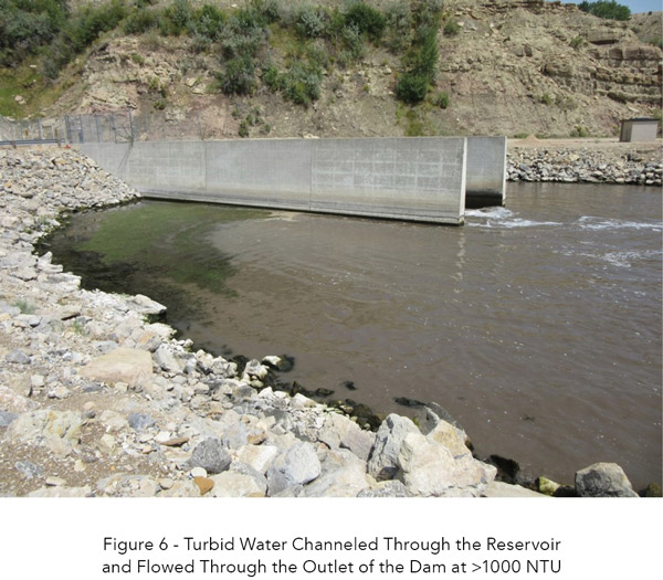
After the fire and resulting debris flows, high turbidity water channeled across the bottom of the reservoir following the prior river channel and came through the Starvation Dam outlet at more than 1000 NTU. This type of flow through the reservoir had never been observed historically. See Figure 6. During this condition, the water near the intake, 2 meters above the bottom of the reservoir, was 61 NTU, with approximately 6 to 8 NTU coming into the plant. The CUWCD mobilized a sampling and monitoring team to evaluate turbidity within the lake. The team sampled several areas at several depths on various days. Figure 5 shows the locations and the turbidity at various depths in the reservoir at one of the sampling locations. The turbidity was impacted by thunderstorms that washed down significant sediment during a storm that produced over 2,000 cubic feet per second in the Strawberry River. Figure 6 shows the flows coming out of Starvation Reservoir when the high turbidity water was channeling through the reservoir and coming out of the dam. This sediment has the potential to shut down this water supply to parts of the Duchesne Valley.
As discussed above, watershed recovery takes five to 10 years to complete. The size of the fire limits the effectiveness of erosion mitigation measures. The ability of the CUWCD to deploy standard mitigation measures is hampered by geology, terrain, and highly erosive soil. There will be some seeding this year to encourage revegetation within the burned area.
Water quality impacts could likely continue for the foreseeable future as the watershed slowly recovers. Although there were a few thunderstorms after the fire, there is still sediment within the watershed with no vegetation to hold it in place. Due to the nature of burned watersheds, it is expected that average storms will produce higher flow rates with larger loads of sediment, organics, and debris. These impacts will taper off as the watershed recovers.
The DVWTP process is not designed to treat high turbidity and is restricted by law. The current process was designed based on past water quality, which was stable for 40 years, and has now been impacted for years to come. These changes will require changes in the treatment process to meet the impacted conditions. The changes may include clarification, with flocculation/sedimentation processes, and may also require alternative water sources.
There may be a potential for emergency funding through the Federal Emergency Management Agency to implement watershed recovery programs or fund plant upgrades to handle the changed conditions. Civil engineers will be considering many of these choices to come up with the solution that will best meet the needs of the community served by the DVWTP in the coming years.
Wildfires are natural disasters that cause impacts to the communities we live in and work with. They increase the chances of flooding, debris flows, and impacts on utility systems like the WVWTP. Civil engineers need to consider the risks of fire and after-effects when designing the systems that serve our communities.
Ben Willardson, Ph.D., P.E., D.WRE, ENV SP, QSD/P
Dr. Ben Willardson has 19 years of professional experience in the development and review of hydrologic, hydraulic, and sediment transport models. During that time, he has managed roadway and pavement improvement projects, pedestrian facility upgrades, and drainage improvement projects. Ben has worked for both the public and private engineering sectors. While working for the Los Angeles County Flood Control District, he oversaw the operation of 14 dams and 27 spreading ground facilities for flood control and water conservation within the complex flood control system serving Los Angeles County. He has conducted asset assessment for programs related to flood-control channels and pavements.

Mike Rau, CUWCD
Mike Rau is the Water Quality Manager for Central Utah Water, where he has been employed since 2009. He has a B.S. in Physiology and Developmental Biology from Brigham Young University, and has grade IV certifications in drinking water treatment and distribution. He is from Mapleton, Utah where he enjoys all things outdoors and spending time with his wife and 5 children.